This article is within the scope of WikiProject Denmark, a collaborative effort to improve the coverage of Denmark on Wikipedia. If you would like to participate, please visit the project page, where you can join the discussion and see a list of open tasks.DenmarkWikipedia:WikiProject DenmarkTemplate:WikiProject DenmarkDenmark articles
This article is within the scope of WikiProject Islands, a collaborative effort to improve the coverage of islands on Wikipedia. If you would like to participate, please visit the project page, where you can join the discussion and see a list of open tasks.IslandsWikipedia:WikiProject IslandsTemplate:WikiProject IslandsIslands articles
Latest comment: 16 years ago2 comments2 people in discussion
02-Sep-2007: The article "Amager" was created almost 5 years ago, on 2-Jan-2003, as text only. After 2.7 years of rare edits, a picture was added each year around August: in 2005 the Hotel photo, in 2006 the Satellite view, and in 2007 the Denmark-islands map. -Wikid77 12:51, 2 September 2007 (UTC)Reply
Christianshavn is not on Amager, Christianshavn is an island of its own, just like Holmen; they both are positioned between Zealand and Amager and connected to them by bridges. I have removed Christianshavn from the description. 88.212.92.13 23:20, 18 October 2007 (UTC)Reply
Latest comment: 16 years ago2 comments2 people in discussion
As one who doesn't live in Copenhagen (much less in Amager), I'd very much like a map as well (or over) as a picture of some random building in Amager. 130.225.54.2 02:55, 28 May 2006 (UTC)Reply
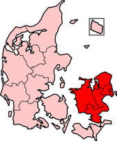
02-Sep-2007: (15 months later) Readable maps have been a challenge for Wikipedia, but I have added a map for Amager, after a year of preparing maps for hundreds of Wikipedia articles. Most map images found on the Internet look too "small and blurry" for Wikipedia use, due to the typical 600-pixel width of the article screen region (with images resized/narrowed below 300px width), and very few readable maps then being free to copy. Due to the tedious work needed in map-making (cartography), Wikipedia maps, typically, have been unusual blurry, blank maps that could be reused dozens of times to "map" many towns/locations against a blank outline of a region. The unfortunate de-facto "standard" had become the red-dot-on-a-diagram map, which was an easy scrawling of a diagram of a region, that did not take the time to draw accurate borders, shorelines or lakes. Crude wiki map merging Zealand+Amager. Even the Denmark maps suffered, with a crude scrawled map of Denmark (see right), highlighting the Zealand island but also overlapping with Amager as though it were part of Zealand. Any wonder others couldn't find "Amager" on a Wiki map, when it was shaded as part of larger Zealand? The future seems to be to expand the "free" CIA maps to include more towns/islands, and also to create special maps from terrain maps (such as the Demis maps of Denmark). Everyone "knows" the need to label a map with words, icons & distance scales, but map-making is very tedious, and the dot-on-diagram gimmick seemed like an easy out, which many people used to avoid map labels and tedious kilometer/mile distance scales. Maps and, in fact, most images were fairly new in 2006, as Wikipedia from 2002 was mostly "wordipedia" expanded from articles containing words, without pictures. Anyway, that intense objection to a "picture of some random building" (versus showing a map) is keenly understood, and I agree that maps are an "absolute must" for decent information. Thank you, User:130.225.54.2, for your suggestion, and even though a year has passed, I agree maps are still crucial for article illustrations. BTW: Several people have actively removed detailed maps from hundreds of articles, as "unnecessary clutter" or "too many names on the map" etc. There have been many technical and social issues which have blocked maps in Wikipedia. Many things to ponder.... -Wikid77 11:54, 2 September 2007 (UTC)Reply
02-Sep-2007: I have added a map of the Denmark islands around Amager (see map at right). Maps are typically for outsiders and can be seen as a nuisance for local people, who are the most likely people to add details about the internal aspects of a town or island. For that reason, I have added a small map (of width 280px), on the verge of being unreadable, so as not to obstruct the focus of local people, but also provide a "click to enlarge" map for outsiders. Beware that other people actively delete such maps for a variety of reasons, including that they are not PNG format (so better to delete them than have GIF images as maps?!). -Wikid77 11:59, 2 Sep 2007 (UTC)
Latest comment: 9 years ago1 comment1 person in discussion
It would be helpful to know how far the Amager end of the Oresund Tunnel is from Copenhagen, and how the bridge/tunnel have been integrated with the transport infrastrucure on Amager. Alfrew (talk) 22:29, 5 September 2014 (UTC)Reply