Navajo Church is a 7,350-foot-elevation (2,240-meter) pillar in McKinley County, New Mexico, United States.
| Navajo Church | |
|---|---|
 South aspect | |
| Highest point | |
| Elevation | 7,350 ft (2,240 m)[1][2] |
| Prominence | 340 ft (104 m)[2] |
| Parent peak | Pyramid Rock[2] |
| Isolation | 0.91 mi (1.46 km)[2] |
| Coordinates | 35°33′27″N 108°36′05″W / 35.5575220°N 108.6014696°W[3] |
| Geography | |
 Navajo Church Location in New Mexico  Navajo Church Navajo Church (the United States) | |
| Location | Navajo Nation |
| Country | United States |
| State | New Mexico |
| County | McKinley |
| Parent range | Zuñi Mountains Colorado Plateau |
| Topo map | USGS Church Rock |
| Geology | |
| Age of rock | Late Jurassic |
| Type of rock | Morrison Formation[4] |
| Climbing | |
| Easiest route | class 5+ climbing[2] |
Description
editNavajo Church is part of the Zuñi Mountains.[1] The landmark is located seven miles (11 km) east-northeast of Gallup and 1.5 miles (2.4 km) north of the town of Church Rock, which is named after the landform. Topographic relief is modest as the summit rises 550 feet (168 meters) above Red Rock State Park in 0.6 mile (1 km). A 2.2 mile (round-trip) hiking trail leads to, and around, the base of the spires.[5] Precipitation runoff from the mountain drains to the Puerco River. Navajo Church is a sacred place to the Navajo people.[6] This landform's toponym has been officially adopted by the United States Board on Geographic Names.[3]
Geology
editThe three spires of Navajo Church are composed of the Westwater Canyon Member of the Morrison Formation which dates to the Late Jurassic.[7] The spires rest atop a pedestal of the formation's Recapture Member. This then overlays Zuni Sandstone which displays spectacular eolian crossbedding on the south face. Successive layers below dropping south to Red Rock Park include Bluff Sandstone, Summerville Formation, and Entrada Sandstone.[8][9]
Climate
editAccording to the Köppen climate classification system, Navajo Church is located in a cool semiarid climate zone (Köppen BSk).[10] The summers are hot during the day, but the high altitude and low humidity mean that nights remain distinctly cool. Most rain falls in the summer from afternoon thunderstorms, and winter snow is common and sometimes heavy.
Gallery
edit-
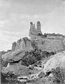 circa 1871–1878
 -
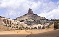 South aspect
 -
 South aspect from Red Rock Park
_Navajo_Church_near_Fort_Wingate,_McKinley_County,_New_Mexico.,_1871_-_1878_-_NARA_-_517770.jpg)

.jpg)
References
edit- ^ a b "Navajo Church, New Mexico". Peakbagger.com. Retrieved 2024-07-02.
- ^ a b c d e "Navajo Church - 7,350' NM". listsofjohn.com. Retrieved 2024-07-02.
- ^ a b "Navajo Church". Geographic Names Information System. United States Geological Survey, United States Department of the Interior. Retrieved 2024-07-02.
- ^ Steven M. Condon, Revisions of Middle Jurassic Nomenclature in the Southeastern San Juan Basin, New Mexico, U.S. Government Printing Office, 1989, p. E13.
- ^ Red Rock Park, Visitgallup.com, Retrieved 2024-07-02.
- ^ Wingate, Theroute-66.com, Retrieved 2024-07-02.
- ^ Orin I. Anderson, New Mexico Geology, August 1989.
- ^ Red Rock Park, New Mexico Bureau of Geology & Mineral Resources, Retrieved 2024-07-02.
- ^ New Mexico Bureau of Geology & Mineral Resources, Retrieved 2024-07-02.
- ^ Peel, M. C.; Finlayson, B. L.; McMahon, T. A. (2007). "Updated world map of the Köppen−Geiger climate classification". Hydrol. Earth Syst. Sci. 11. ISSN 1027-5606.
External links
edit- Navajo Church: weather forecast